Designing Tomorrow Together
Digital Data is drastically improving our ability to understand the world around us. Some of our data-driven solution showcases how big data and new technologies allow cities and local communities to seize new opportunities to increase productivity in agriculture, deliver efficient energy and health-care services, effective asset management and resource mapping, prepare for disasters; transform digital achieve and knowledge management of cultural significant archelogy and target assistance to those who need it most.
1. Policy, Advocacy, and Communication Enhanced for Population and Reproductive Health (PACE Nepal)
National averages and standard measures mask the complexity of family planning and fertility dynamics in Nepal. With a Total Fertility Rate (TFR) approaching replacement levels, one could conclude the family planning needs of Nepali men and women are close to being met. This presentation takes a closer look at a fertility rates and changes among an important subgroup, adolescents between the ages of 15 and 19. The health and opportunity costs of adolescent childbearing are well documented. The presentation shares estimates of adolescent fertility for 2016 for 79 municipalities in Karnali Province. Over the period 2011 to 2016, most municipalities in Karnali province experienced declines in adolescent fertility. However, in a small number of municipalities adolescent fertility remained high and relatively unchanged over the time period. The results shared here provide ministry and municipal authorities, development partners and advocates seeking to reduce adolescent childbearing with new information to better understand adolescent fertility dynamics in the province and to better target program responses, including family planning efforts.
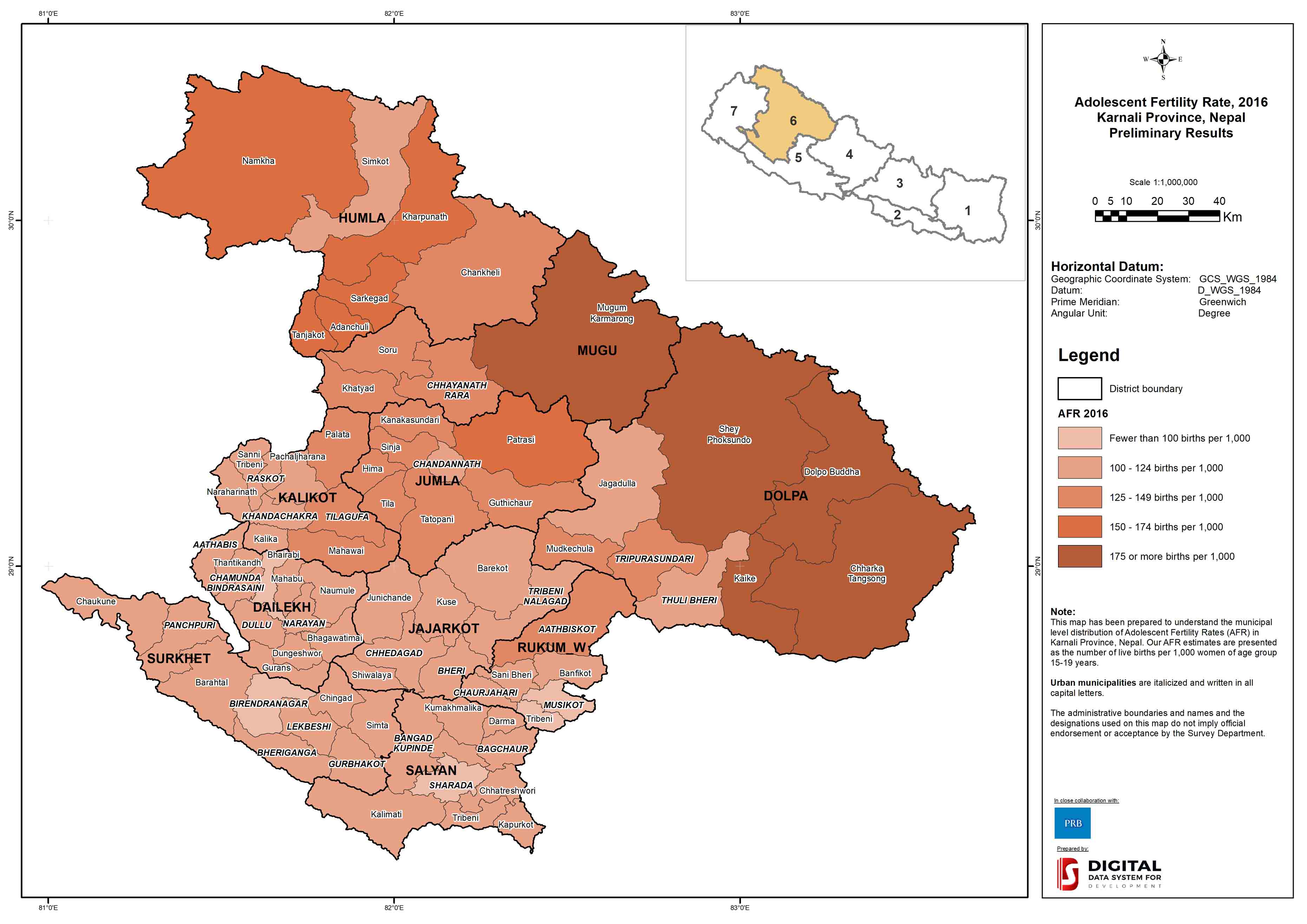
The results shared here provide ministry and municipal authorities, development partners and advocates seeking to reduce adolescent childbearing with new information to better understand adolescent fertility dynamics in the province and to better target program responses, including family planning efforts. The purpose of convening is to identify ways in which municipal estimates of recent adolescent fertility change may be improved prior to expanding the analysis to all 753 municipalities in Nepal.
2. Modeling Demographic Profile
Understanding population dynamics and heterogeneity (by education, health, income, place of residence, states, etc.) within a country provides important insights for explaining social and environmental changes. It also helps to identify vulnerable sections of the population that are affected most by these changes. Projections of population dynamics and heterogeneity can serve as a prediction that assists policymakers and other stakeholders in visualizing an alternative future, to assess what-if scenarios, or to simulate sensitivity tests of single or multiple variables. While demographers are interested purely in population dynamics, the users of population projections are spread in many disciplines, among them development studies with a focus on Sustainable Development Goals (SDG).
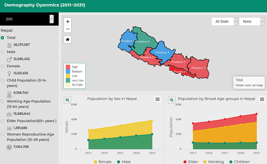
Perform High quality statistics & projections of the population for policy development and for planning and providing public services
We can monitor and prepare your big data with rapid advances in machine learning, coupled with cheap cloud computing, allow us to draw meaningful insights in real time from satellites, statistical data, sensors network, crowd-sourcing, and phone.
3. Enabling Digital Agriculture
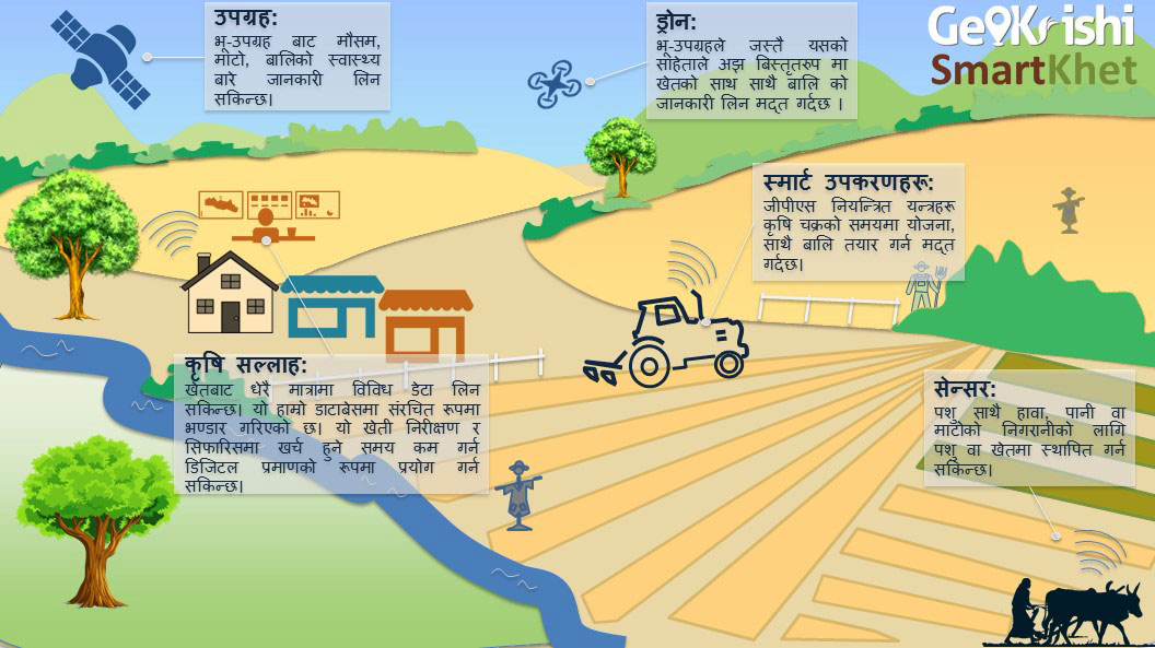
What to Grow, When, Where and How
Nepal has an immense diversity in terms of geographic, topographic and climatic conditions. We leverage these opportunities to enable location-specific information services by simplifying and amplifying the work of farmer/intermediator using scientific methodology. We integrate government, geo/biophysical (slope, aspect, elevation, sunshine and soil parameters) data & crowd-source agricultural data that helps to manage risk, increase crop productivity and maximize profit.
4. Demography and Health Target & Coverage
In Nepal, many depend on public health services and the health resources are allocated to public health managers based on targets and inputs from different health and demographic models. It is therefore critical that estimates are accurate. Our population model based on the state-of-the-art scientific methodology along with the latest available data from various sources developed by Samir KC that includes projections of the population by various demographic and socio-economic characteristics.
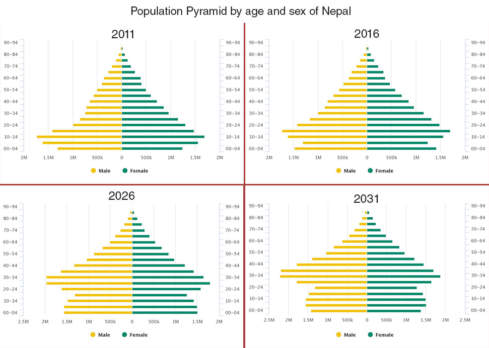
Demographic data for Public Health Managers
We have developed and packaged results along with useful functionality into a user-friendly website and app. It includes annual demographic targets as needed by DoHS and the Ministry of Health for the planning, monitoring, coordination, supervision, and evaluation of health and population related policy and budget preparation - resource allocation, setting health commodities targets and logistics management.
5. Profiling at Federal, Provincial & local levels
Nepal's new federal system fundamentally transforms the nature of central governance to much more dispersed system of administration.
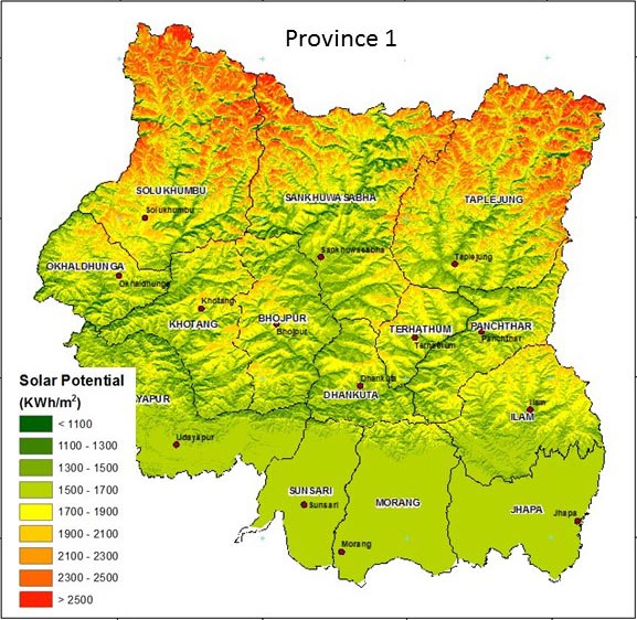
We prepare profile of National, provincial and local administration
We can monitor and prepare your big data with rapid advances in machine learning, coupled with cheap cloud computing, allow us to draw meaningful insights in real time from satellites, statistical data, sensors network, crowd-sourcing, and phone.
6. Digital Inventory of Cultural Heritage
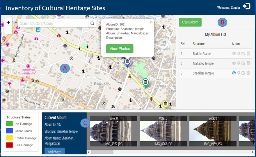
We define the entire process of CH preservation and promotion through three different levels of project activities:
- Inventorying for future generation
- Analyses for provide better insight on our past and monitoring structural health for our future
- Promoting through publishing
Inventory, protection and management of existing heritage structures require appropriate and effective tools and techniques to support documentation, diagnosis and structural analysis phases in order to validate expected performance. We provide state-of-the-art facilities and approaches through our multidisciplinary engineering and multinational team for the development of a risk based analysis tool to support the decision making process on heritage inventory, protection and management to natural disasters.
7. Initiatives
Database to Map
In Nepal, GIS is only being used by technically and financially advanced institutions in their respective focus areas. Whereas, there is no denying the fact that the prospects of using GIS are much beyond just a few limited institutions. GIS, has the capability to improve effectiveness, efficiencies and can support useful decision for anyone from an individual, to a large institution.
Map-making has the potential to be a change making tool in many ways and such tools should be easily accessible to all. We believe that we can empower people to make change happen if right tools are provided. We are on a mission to make map-making quick, affordable and useful for everyone. Thus, allowing for expressing their ideas, visualize their cause and tell their story with maps to masses. We stand by our vision of making map-making as easy and as useful as a web-search engine.
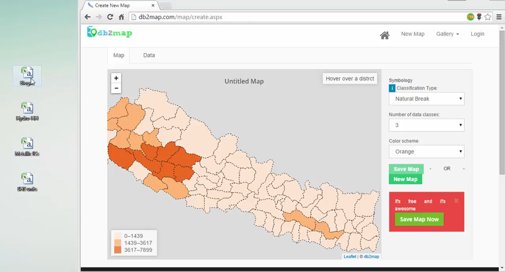
What Do We Want To Do?
Complement organization and their initiatives and foster open collaboration as we foresee this as an essential tool to integrate interdisciplinary open data layers with a cross-cutting elements for better understanding of specific area. Draw upon the professional, technological, and entrepreneurial expertise of different areas, strengthening their respective capabilities and fulfilling open data practices.
Geokrishi
Nepal has an immense diversity in terms of geographic, topographic and climatic conditions. However, intervention to increase crop productivity with pest/diseases control, randomly promote cash crop and over utilization of fertilizer are not sufficient in the context of changing climate, population growth and degradation of resources. More specifically and importantly, information such as bio-physical, climatic and agro economic information are useful but contextualize them to get the relevant information is harder to find.
Our mission is to simplify and amplify the work of farmer/intermediator by adopting scientific methodology to provide location specific-timely actionable informationto increase farm productivity and maximize profitability.
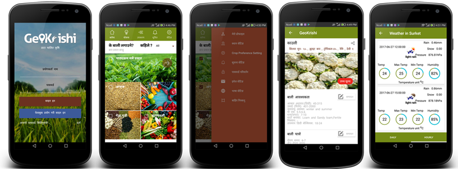
Objectives
- Establish agricultural data infrastructure incorporating several data, products and tools useful for overall agricultural stages.
- Remove technical and cultural barrier in the most simple and cost-effective way such that anyone can monitor real-time information from the farm.
- Empower extension worker to provide better recommendation to the farmer through our district level agriculture advisory services center.
 Current Nepal